Thursday 30 September 2010

Sundogs!

Solar atmospheric phenomenon viewed from Granitehill about 2.30pm today.


The two rainbow-tinted patches of light flanking the sun on both left and right are called sundogs. Caused by floating ice crystals drifting high in the atmosphere and more usually seen when the sun is almost at the horizon in early morning or late evening, sundogs are a rare-enough phenomenon to observe from a city location in the mid-afternoon.

Watch the skies!
http://atmospherical.blogspot.com/

Monday 13 September 2010

Save the Unicorn!


Saved! This unicorn by famed Aberdeen monumental mason Jack Ruddiman of Merkland Road has been saved twice. First with the demolition of Holburn St. School where he sat on the apex of the street-facing gable.

The unicorn then took pride of place on the Holburn St. frontage of the modernist slab and block building occupied by the College of Commerce which was built on the site of the former school. After that building was condemned, for about a decade the unicorn was ignominously protected by a plywood box mounted on the gable end.

Talisman House now occupies the site, but that après-post modern edifice could not find space for our mythical herald. So now he sits quietly in a corner of the reception area of ACC's Broad Street offices, seen only by those who know he's there.

We think that's a shame. It's time he was outside again.

The A to Z of Aberdeen - F

F is for Farms. And Farriers. And Footpaths.

All it takes is a few minutes leafing through a book like Diane Morgan's Lost Aberdeen or Winram Cluer's Walkin' The Mat to set us off imagining the psychogeography of Aberdeen before the modern era; mentally stripping away the buildings of the last century or more to reveal the vistas of hills and glens and watercourses and woods which they obscure. We find ourselves notionally erasing the newer roads and streets leaving the more ancient highways and footpaths which connected places of economic, spiritual or civic meaning to the people who inhabited the more natural topography of the times.

Of course, such imaginings themselves are part of the process of psychogeography, a process aided by the buildings which have survived longer than they might have and byways which have been bypassed, but vestigially remain for us to explore.

Old Mill Road. An ancient byway linking The Green
to the Justice Mills. Bypassed by the Hardgate!

It's surprising how much of the rural agricultural centres of the settlements which preceded Aberdeen's 19th and 20th century development remain.

Outseats Farm - at the southernmost end of the Hardgate.

Balmoral Terrace, off Broomhill Road

Cottage Brae - off Nellfield Place

Friendship Farmhouse - Ashley Road
Friendship Farm workers' cottages. Friendship Terrace


Newlands Mill - much altered.
Off the line and below the level of Newlands Crescent
The semi- or pre-industrial infrastructure which supported the rural economy is often still legible in the urban environment today, as we see above, some mills survive, but the past is most notable in the steadings, stables and farriers which have survived by morphing into motor-trade infrastructure and enterprises. We can imagine it happening - early 20th Century, as the horse is being shod, the farrier is asked by the footman: "Can you get some of that petroleum essence for the master's new-fangled horseless carriage - we've no idea who else to ask." Over time, more and more of the farriers' business was looking after motorcars: fewer horses, more cars. At some point, the day came when there were no horses left in the city at all, but the farriers' business continued on the same site.

The function of this stable has remained, um, stable

Bruce Motors, Hardgate.

Salisbury Terrace - this farrier's premises is still doing the same job as ever;
looking after your transport.


Blenheim Lane - former steading
Blenheim Lane - early 20th century garage infrastructure
tacked onto front of steading. We can imagine a hand-pumped
petrol dispenser having pride-of-place beneath the canopy.
Blenheim Lane steading - scrap metal dealing in the yard.
 A modern day knacker's yard?

No change, really.

Gairnhill Hooverville.

Over the summer we couldn't help but notice the proliferation of rough shelters in the woods around Aberdeen. Back in the spring we first noticed a young couple gathering switches in the West Woods of Craibstone - further along, we came across their nearly-complete drum-shaped wickiup complete with food supplies and sleeping bags. We didn't really think very much about it at the time - if anything, we thought it was quite romantic. We didn't photograph it, as it was clearly inhabited.

However, throughout the summer, we've seen more and more evidence of people actually living in the woods. These rough shelters are springing up in Clinterty Woods, Tollohill and most notably Gairnhill and Countesswells Wood, where we've noticed about a dozen in various stages of construction and habitation.

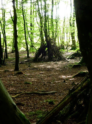
This one's unfinished

This put us in mind of the "Counteswells Hermit" as documented by the Aberdeen Tramps and Ither Weel Kent Fowk blog. We've not noticed this fella in a while - we did often see him in the past - from time to time he would walk past the front window of our studio in fabulous downtown upscale Pitmuxton but we can't remember having seen him any time in the last few years. We naturally worry that his outdoors lifestyle has led to his natural demise.

Are these wigwams, tepees and lean-to's a conscious artistic homage to the memory of the Counteswells Hermit? Are they trysting-hideouts for romantic young couples who lack a private space of their own, being priced out of property to buy or even lease? Or are they the first foundations of our own Aberdeen Hooverville? We know that the non-oil and gas economy's bad - but it's surely not that bad. Or is it?